 |
 |
 |
 |
 |
 |
 |
 |
 |
| |
|
|
|
|
|
|
|
|
|
|
|
|
|
|
|
|
|
|
|
|
|
|
|
|
|
|
|
|
|
|
|
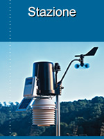
L'osservatorio meteorologico di Castagneto Po è operativo dal 25 luglio 2005. |
|
|
|
|
|
|
|
|
|
|
|
|
|
|
|
|
|
|
 |
|
|
|
|
|
|
|
|
|
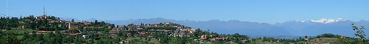
Comune: Castagneto Po |
|
|
|
 |
|
|
|
|
|
Località: Centro inferiore |
|
|
|
|
|
Provincia: Torino |
|
|
|
|
Latitudine: 45° 09' 38" Nord |
|
|
|
|
|
|
|
|
|
Longitudine: 7° 53' 24" Est |
|
|
|
|
|
Altitudine: 470 m s.l.m. |
|
|
|
|
|
|
|
|
|
|
 |
|
|
|
|
|
|
|
|
|
|
|
|
|
|
|
|
|
|
|
|
|
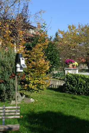
Ubicazione: semi-urbana |
|
|
|
 |
|
|
|
|
|
Tipo ubicazione: giardino |
|
|
|
|
Esposizione: Sud |
|
|
|
|
|
|
|
|
|
|
|
Ore insolazione inverno: min. 6 h (9:30-15:30) |
|
|
|
|
Ore insolazione estate: max. 12 h (6:30-18:30) |
|
|
|
|
Altezza dal suolo sensori: 180 cm |
|
|
|
 |
|
|
|
|
|
Schermo solare: ventilato a 10 piatti |
|
|
|
|
|
|
|
|
|
|
|
|
|
|
|
|
|
|
|
|
|
Costruttore: Davis Instruments |
|
|
|
|
Modello: Vantage Pro 2 wireless |
|
|
|
|
|
|
|
|
|
|
|
|
|
|
|
|
Sensori: termo-igrometro, barometro, anemometro, pluviometro, radiazione solare |
|
|
|
|
|
|
|
|
|
|
|
|
|
|
|
|
|
|
|
|
|
|
|
|
|
|
|
|
|
|
|
|
|
|
|
|
|
|
|
|
|
|
|
|
|
Responsabile: Marco Castello - Socio S.M.I Società Meteorologica Italiana - Socio MeteoNetWork |
|
|
|
|
Contatti: info@osservatoriometeorologicodicastagnetopo.biz |
|
|
|
| |
|
|
|
|
|
|
|
|
|
|
|
|
|
|
|
|
|
|
|
|
|
|
|
|
|
|
|
|
|
|
|
|
|
|
|
|
|
|
|
|
|
L'osservatorio meteorologico di Castagneto Po aderisce alle seguenti reti di rilevamento: |
|
|
|
|
Rete rilevamento regionale TorinoMeteo |
|
|
|
| |
Link http://www.torinometeo.org |
|
|
|
|
|
|
|
|
|
|
|
|
|
|
|
|
|
|
|
Rete rilevamento nazionale Meteonetwork - Centro Epson Meteo |
|
|
|
| |
Link: http://www.meteonetwork.it |
|
|
|
|
Rete rilevamento nazionale Linea Meteo |
|
|
|
|
Link: http://www.lineameteo.it |
|
|
|
| |
Rete rilevamento mondiale Weather Underground |
|
|
|
| |
Link: http://www.wunderground.com |
|
|
|
| |
Rete rilevamento mondiale AWEKAS - Automatic Weather Map System |
|
|
|
| |
Link: http://www.awekas.at |
|
|
|
| |
|
|
|
|
|
|
|
|
|
|
|
|
|
|
| |
 |
|
|
|
|
| |
|
|
|
|
|
|
|
|
|
|
|
|
|
|
| |
 |
|
|
|
|
| |
|
|
|
|
|
|
|
|
|
|
|
|
|
|
|
 |
|
 |
|
|
|
|
|
|
|
|
|
|
|
|
|
|
 |
|
|
|
|
|
|
|
|
|
|
|
|
|
|
|
|
|
| |
|
|
|
|
|
|
|
|
|
|
|
|
|
|
|
| |
|
|
|
|
|
|
|
|
|
|
|
|
|
|
 |